Riverine and coastal erosion leading to depopulation of Ghoramara Island
Core Event Data
INDIA-RE-1001
Riverine and coastal erosion leading to depopulation of Ghoramara Island
India
West Bengal
South 24 Parganas
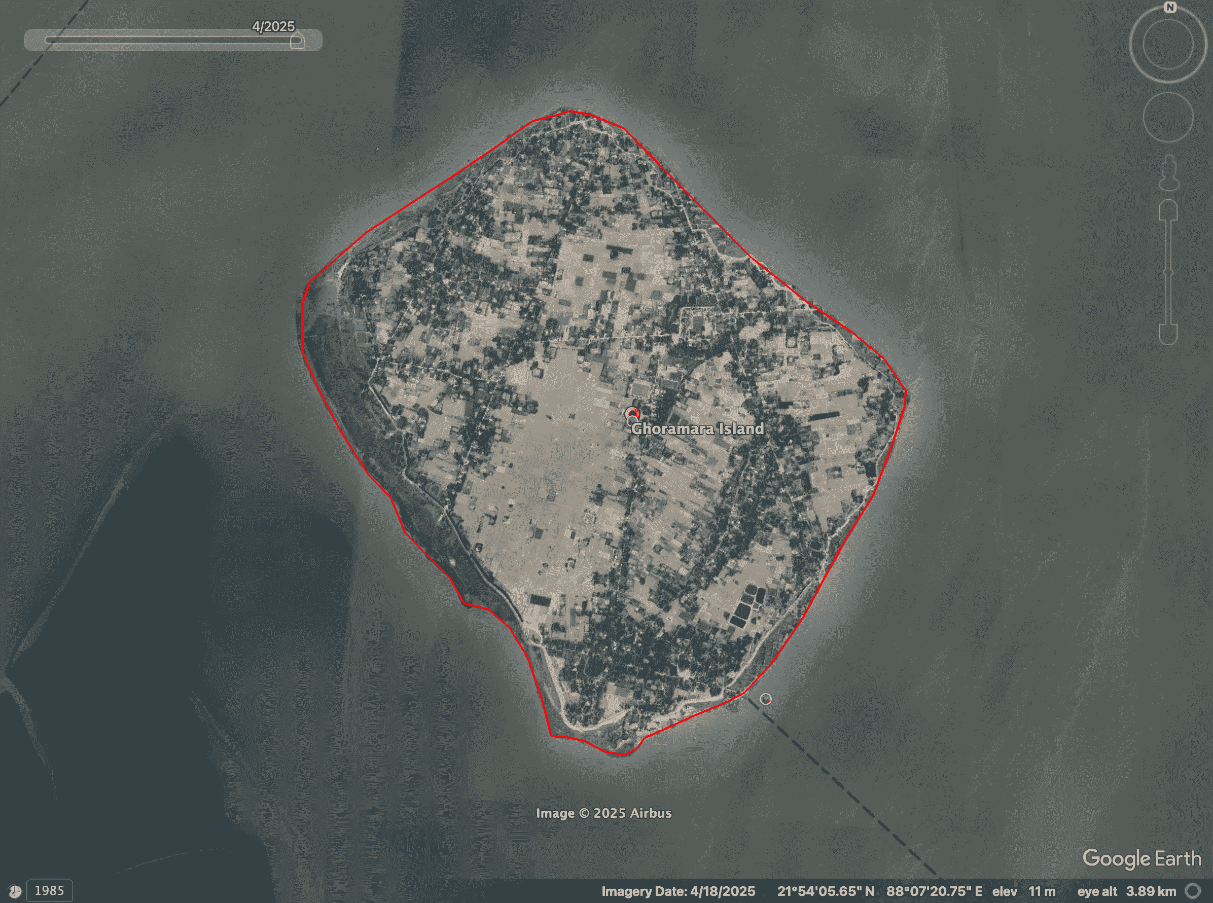
Ghoramara Island, Sagar CD Block, Hooghly estuarine delta (Sundarbans fringe)
1970 s (documented onset of rapid erosion phase)
Ongoing
Ghoramara Island has undergone severe and continuous land loss due to tidal and riverine erosion in the Hooghly estuary. Scientific studies and government records confirm significant reduction in island area over multiple decades, permanent loss of settlements and agricultural land, and out-migration of residents to nearby islands such as Sagar.
Population data from the Census of India shows a clear decline over time, directly linked to erosion-induced land loss. The island represents a slow-onset climate-linked displacement system, where habitation becomes progressively unviable.
The island is rapidly losing its morphology due to extensive coastal erosion, particularly on the northwestern coast. Over four decades (1972–2010), the island lost approximately 50% of its area, shrinking from 941.76 hectares to 488.43 hectares. Inhabitants, described as “environmental refugees,” have been forced to leave due to the degradation of their natural habitat and the total submergence of neighboring islands like Lohachara.
The Climate Displacement Lab’s study of the island through satellite images found that as of 18 April 2025, the total area of the island had reduced to 388 hectares.
Hazard Details
Primary Climate Hazard Displacement
Direct
Climate
Hydrological
Slow
Erosion
Sea Level Rise
Yes
Sudarbans Delta
Displacement Impact
2000
600
Forced
12
temporary
Dispersed across districts
1
mixed
941.76 ha
Sagar Island
Yes
Displacement from Ghoramara Island has occurred gradually over several decades, resulting in a dispersed and largely unplanned relocation pattern rather than a single organized resettlement. Most affected households have moved to nearby Sagar Island, as well as mainland areas of South 24 Parganas such as Kakdwip, while some have migrated further to urban and peri-urban centers including the Kolkata region for livelihood opportunities. Relocation has been driven primarily by repeated homestead loss due to erosion and facilitated through kinship networks, informal settlement, and limited state-supported relocation, without a comprehensive rehabilitation framework.
As a result, displaced populations are spread across multiple locations in fragmented clusters, often living within host communities on land with insecure tenure, and in some cases experiencing repeated or secondary displacement due to continued environmental vulnerability.
mixed
Livelihood
No stable source of income, Subsistence farming, Daily wage labor
Subsistence farming, Livestock herding, Fishing or aquaculture, Small-scale business/trade, Daily wage labor, Artisanal work (e.g., crafts, weaving)
There has been a drastic reduction in the island's primary productive resources between 1972 and 2010. Specifically, cultivated paddy fields decreased from 297.72 hectares to 113.49 hectares, and fisheries decreased from 4.68 hectares to 1.71 hectares. According to research, 80% of residents changed occupations; most farmers became wage laborers.
Governance & Legal
limited
Government intervention has been partial and uneven, including relocation of some families from Ghoramara to Sagar Island and provision of basic assistance. However, there is no comprehensive or sustained rehabilitation policy covering all displaced households, and much of the relocation has been self-managed.
partial
Rehabilitation for the displaced inhabitants of Ghoramara Island is defined as a process involving the rebuilding of economic and physical livelihoods, developing socio-cultural links, and fostering psychological acceptance of an altered environment. While thousands have been affected by the shrinking landmass, formal government-led rehabilitation has occurred in specific historical phases, primarily targeting relocation to Sagar Island. Rehabilitation of displaced households from Ghoramara Island occurred in distinct phases with progressively reduced land allocation per family. In the 1981–82 phase, approximately 45 families were resettled in Fuldubi and Gangasagar on Sagar Island, each receiving about 6 bighas (≈0.97 hectares) of land. During the 1989–90 phase, a larger group of around 100 families was relocated to Manasadwip–Jibantala and Manasadwip–Khasmal, also on Sagar Island, but land allocation decreased to 3 bighas (≈0.48 hectares) per family. By 1996, about 36 families were relocated, followed by an additional 5–6 families shortly thereafter, with land allotment further reduced to 1.5 bighas (≈0.24 hectares) per family, reflecting a clear downward trend in rehabilitation support over time. Relief and rehabilitation support for displaced households from Ghoramara Island included a combination of immediate assistance, housing, livelihood support, and limited preparedness measures. In the immediate aftermath of displacement, families were provided with basic relief materials such as tarpaulins and blankets, along with food aid—reported as 300 grams of wheat and 500 grams of rice during later phases. To support resettlement, around 80% of families relocated during the 1989–90 phase received houses constructed under the Indira Awas Yojana. Livelihood assistance included government support for pond excavation in rehabilitation villages, as well as the distribution of fruit and vegetable saplings accompanied by training under the MGNREGA scheme to facilitate early income generation. In terms of preparedness, a multipurpose cyclone shelter was established at Ghoramara Milan Vidyapith, providing temporary refuge for residents during periods when homes are damaged or threatened by erosion. Existing management efforts in rehabilitation and embankment construction are described by researchers as not satisfactory. Because formal rehabilitation has ceased, many inhabitants now engage in inter-island migration or move toward the mainland. Some families independently purchase land and construct houses in areas like Namkhana, Kakdwip, and Kolkata. There is an urgent call for the government to restart rehabilitation immediately and ensure people are compensated by either money or land elsewhere. Experts argue that without controlled erosion or renewed rehabilitation, the population pressure on nearby Sagar Island and Kakdwip will become fatal.
Land-for-Land Compensation, Permanent Housing, Safe Relocation Site, Basic Infrastructure (Roads, Electricity), Riverbank Protection Measures, Embankment Construction
No
No
Residents of Ghoramara have consistently expressed the need for secure resettlement, housing, and erosion control measures, including embankments and riverbank protection. Studies highlight demands for land rights and formal recognition at relocation sites, as many displaced households lack secure tenure after migration. However, there is no consolidated evidence of formally institutionalised demand submission processes, and responses have remained fragmented.
No Rehabilitation Plan Provided, Inadequate Compensation, Not Recognised as Climate-Affected, State Failed to Prevent Erosion/Flooding, Failure of Embankment or Protection Infrastructure, Repeated Displacement Without Durable Solution, Loss of Livelihood, Loss of Agricultural Land, Loss of Housing, Increased Debt or Financial Hardship, Property Destroyed
No
No
Research on Ghoramara highlights persistent grievances related to loss of land, housing, and livelihoods without adequate compensation or long-term rehabilitation planning. Residents face repeated displacement due to continued erosion, while protective infrastructure such as embankments has been insufficient or ineffective. Many displaced households report economic hardship and insecure living conditions at destination sites, alongside the absence of formal recognition as climate-affected populations.
For Ghoramara Island, the relevant legal and policy framework includes the Disaster Management Act, 2005 (notably Sections 2(d) defining disasters, 12 on minimum standards of relief, and 22 & 24 outlining state responsibilities for disaster response), the National Action Plan on Climate Change (NAPCC) (particularly the National Mission on Sustainable Habitat and National Water Mission addressing climate resilience), the Coastal Regulation Zone (CRZ) Notification, 2019 (including CRZ-I and CRZ-IV classifications and provisions under Para 3 and Para 8 regulating activities in vulnerable coastal zones), and the West Bengal State Disaster Management Plan, which provides for risk assessment, relief, and rehabilitation mechanisms; however, critically, none of these frameworks explicitly guarantee relocation rights, land-for-land compensation, or legal recognition for populations displaced specifically by slow-onset erosion.
Response has been fragmented across agencies, with limited coordination between disaster management, land administration, and climate adaptation frameworks. While relocation to Sagar Island demonstrates some level of state engagement, the absence of a dedicated climate displacement policy has resulted in long-term gaps in rehabilitation, tenure security, and livelihood restoration.
Sources
Non-governmental organisation, Media, Academic
Morphological Change Study of Ghoramara Island, Eastern India Using Multi Temporal Satellite Data
https://www.isca.me/rjrs/archive/v1/i10/13.ISCA-RJRS-2012-319.pdf
Climate Change, Displacement, and Managed Retreat in Coastal India
https://www.migrationpolicy.org/article/climate-change-displacement-managed-retreat-india
High